- Map showing Artic Native American Indians
- Map showing Sub-Artic Native American Indians
- Map showing Northwest Coast American Indians
- Map showing Northeast - Eastern Woodland Indians
- Map showing Plateau American Indians
- Map showing Great Plains American Indians
- Map showing Great Basin American Indians
- Map showing Southeast American Indians
- Map showing Southwest American Indians
- Map showing California American Indians
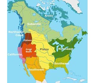
Native American Map
The Native American Map shows the location of famous tribes in the areas as detailed below. - Tribes of Great Plains Indians: The Map indicates this area was inhabited by Native Indian tribes of the Pawnee, Arapaho, Sioux, Cheyenne, Crow, Comanche - the Blackfoot tribe also lived in this area
- Tribes of Northwest Coast Native American Indians: The Map indicates this area was inhabited by the Chinook Native Indian tribe - the Haida, Eyak, Coast Salish, Tlingit, Tillamook and Chimakum tribes also lived in this area
- Tribes of Northeast Eastern Woodland Indians: The Map indicates this area was inhabited by Native Indian tribes of the Miami, Lenape, Iroquois, Massachusett, Powhatan, Abenaki, Shawnee and Pequot - the Fox, Sauk, Wampanoag, Delaware, Huron (Wyandot), Mohawk, Mohican and Menominee tribes also lived in this area
- Tribes of Plateau Native American Indians: The Map indicates this area was inhabited by Native Indian tribes of the Nez Perce and Yakima - the Klamath, Modoc, Salish (Flathead) and Walla Walla tribes also lived in this area
- Tribes of Great Basin Native American Indians: The Native American Map indicates this area was inhabited by Native Indian tribes of the Shoshone and Paiute - the Ute and Bannock tribes also lived in this area
- Tribes of Southeast Native American Indians: The Map indicates this area was inhabited by Native Indian tribes of the Natchez, Cherokee, Chickasaw, Choctaw, Creek and Seminole
- Tribes of Southwest Native American Indians: The Map indicates this area was inhabited by Native Indian tribes of the Pueblo, Apache and Navajo - the Hopi, Zuni and Yuam tribes also lived in this area
- Tribes of California Native American Indians: The Map indicates this area was inhabited by Native Indian tribes of the Chumash - the Hokan, Maidu, Miwok, Pomo and Serrano tribes also lived in this area
- Tribes of Sub-Artic Native American Indians: The Map does not indicate this area but it was inhabited by Native Indian tribes of the Ingalik, Kuchin, Beaver, Chippewa (Ojibwa), Cree and Naskapi
- Tribes of Artic Native American Indians: The Map indicates this area was inhabited by Native Indian tribes of the Aleut, Inuit and Tlingit
Native American Map - Migration of Tribes
Many of the Indian tribes migrated to different areas following contact with the Europeans and made homes throughout the North American continent. The introduction of the horse, leading to the Indian Horse Culture, by the Europeans made the area of the Great Plains very appealing due to the plentiful buffalo that roamed across the prairies and plains. - Tribes including the Winnebago, Iowa, Otoe, Omaha, Kansa, Osage, Sioux or Dakota, Pawnee, Hidatsa, Crow and the Mandan people migrated to different areas ranging from the northeast, the southeast, the Plains and Northern California.
|